Project Updates
The Union SWCD has made a good-faith effort to provide the most updated and accurate information about the Buffalo Flats Floodplain project for our conservation partners and the interested public on the several pages of this website. We have attempted to organize this information in a way that makes it easy to find and read. Please reach out to our staff by email, phone, or visits to our office if you have any questions or concerns about this project and information provided. With our small staff and a heavy workload, new information may be available that is not posted yet. The Union SWCD provides monthly updates of design and planning products to the Union City Council and periodically to the Focus Group as the project completes milestones noted in the timeline.
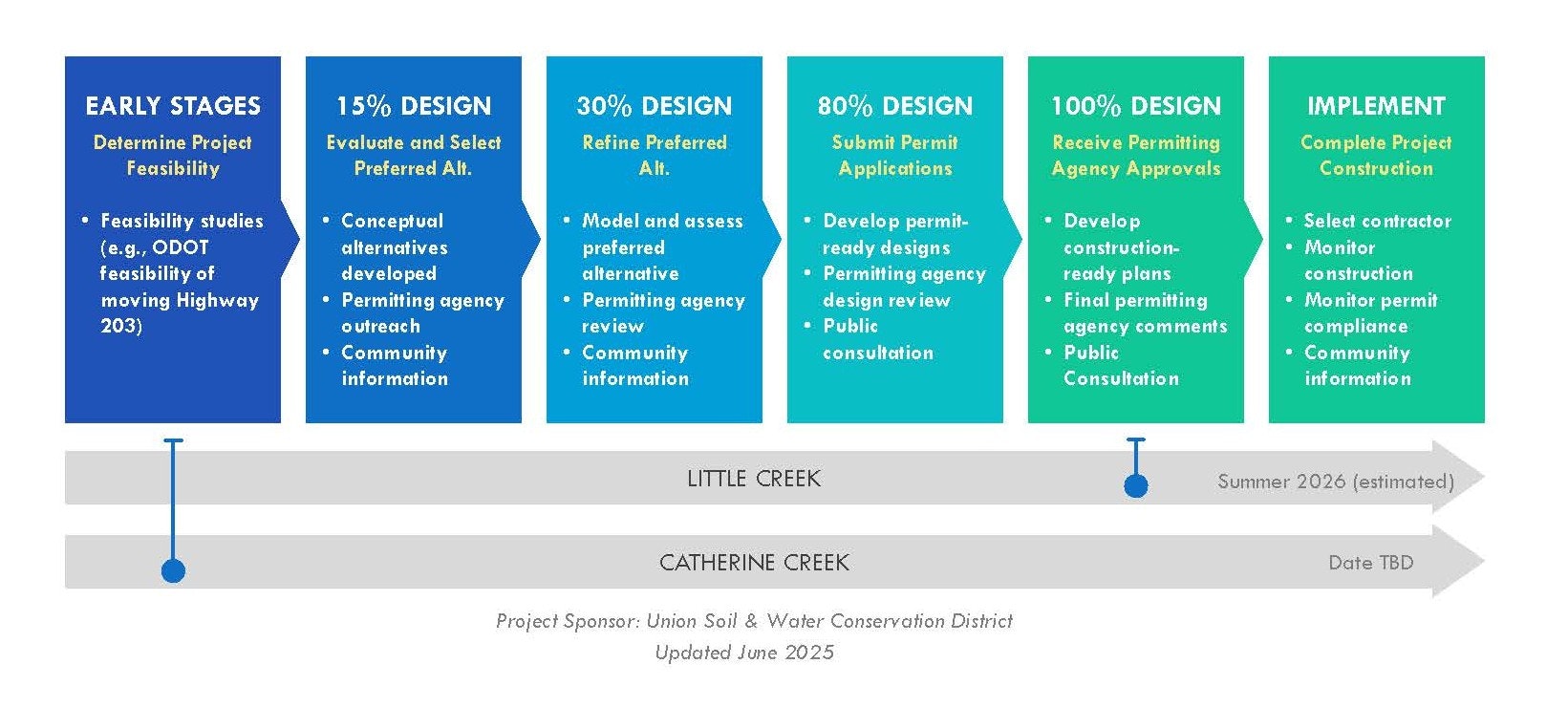
The Buffalo Flats Floodplain Planning project includes both Little Creek and Catherine Creek on property owned by Buffalo Peak Land & Livestock, LLC. Little Creek and Catherine Creek restoration designs are on separate timelines because of differences in their size and scale, physical modifications and infrastructure, and water rights that must be considered. The accuracy and quality of analysis is much higher if the two stream systems are evaluated separately, while still considering the entire project as a combined area. Due to its lesser complexity, Little Creek is furthest along; on-ground project activities in Little Creek are expected to start prior to activities on Catherine Creek.
June 2025
Little Creek: The Final Design package is now finished and is being posted on this website! The Final Design has been approved for construction through a detailed review by a regional team of regulators and scientists (led by BPA). The Final Design package will be provided to the City of Union City Administrator and Floodplain Manager for evaluation of the proposed actions, flood risk analysis, and compatibility with City of Union ordinances and zoning designations. The Union SWCD will also provide a written response to the Letter of Opposition recieved in March 2025 from the City of Union to address concerns and questions from the community. Comments and concerns received to date have been addressed to the best of our abilities and knowledge in the Final Design package.
The design team continues to complete all regulatory and environmental requirements necessary for construction. Cultural resources surveys and test pits were completed in September 2023 and Oregon State Historic Preservation Office concurred with findings in May 2024. Endangered Species Act requirements were completed through BPA's Habitat Improvement Projects programmatice Biological Opinion (HIP IV). The requirements of the National Environmental Policy Act (NEPA) are being completed by BPA as this project action was analyzed in the 2020 Columbia River Basin Tributary Habitat Restoration Programmatic Environmental Assessment (DOE/EA-2126). BPA is preparing a Supplement Assessment to the Programmatic EA to document any environmental effects outside of the original analysis. Clean Water Act 401 requirements will be completed with a water quality certification from Oregon Department of Environmental Quality and Clean Water Act 404 will be met with a Regional General Permit through the U.S. Army Corps. of Engineers. A removal/fill permit will be obtained from Oregon Department of State Lands. A floodplain permit and Land Use Compatability Statement has been received from the Union County Planning Department.
Construction funds have been pursued by submitting proposals to several agencies. Funding has been awarded from BPA and the Oregon Watershed Enhancement Board (OWEB). Construction is being planned to begin during the fall of 2025 and through the summer of 2026, dependent on aquiring the final regulatory permits and clearances.
Monitoring for project changes and effectiveness to meeting project objectives will continue on the project site. Stream discharge and temperature is measured on a monthly frequency at upstream boundary of the project (Kofford Road) and downstream boundary near the Eastern Oregon Livestock Show grounds. Three permanent groundwater monitoring wells (piezometers) were installed in the western portion of the meadow to measure the depth to the free water surface throughout the year. A common objective for floodplain restoration projects is to raise the elevation of groundwater in relation to the ground surface and surface stream channels. The three monitoring wells installed adjacent to Little Creek will not be used to pump or remove water but will provide a way to continually measure and observe groundwater elevation, especially in relation to the surface water elevation in Little Creek.
Catherine Creek: At the request of the Union SWCD and the technical team, the Oregon Department of Transportation (ODOT) is assisting by conducting a feasibility study and cost estimates for alternative alignments of Highway 203 along Catherine Creek on the Buffalo Peak Land & Livestock property. ODOT began this work in summer 2023 with site surveys to develop an elevation layer of the area. Alternatives for a new alignment and location of Highway 203 are being developed with consideration of safety concerns, maintenance, weather impacts, construction feasibility, cost, and environmental impacts. This feasibility study is scheduled to take place through 2024. The Catherine Creek portion of the project and potential changes to the alignment of Highway 203 are only conceptual ideas at this time. No designs have been developed and no action is being taken for actual on-ground construction.
The following timeline diagram illustrates the progress of both the Little Creek and Catherine Creek portions of the project.
Public Outreach: Union SWCD continually updates the project’s online Frequently Asked Questions page and resource sheets. Any significant project updates or additional resources will continue to be posted to this website page. We are also continuing to coordinate directly with our Union City Council laisons and other community groups to share information and receive feedback that helps us communicate project actions with the public and understand community concerns.
The Union SWCD welcomes any questions and inquiries about the project. If you have questions or want to discuss the project, please contact us at 541-963-1313 or email Jim Webster at jwebster@unionswcd.org or Aaron Bliesner at abliesner@unionswcd.org.